News
We bring you the latest News for campers and caravanners.
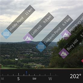
See beyond the map with OS augmented reality
Mapping expert Ordnance Survey has taken its popular OS Maps application to a new level with the introduction of augmented reality technology.
The new feature means you can easily identify hills, towns, woods, lakes, coastal and other points of interest by pointing your phone at them and seeing them labelled on the image shown through its camera. If the label is pressed and your phone has a data connection, you can even tap on them to find out useful information about the highlighted places, including nearby walks, photos and places to stay.
Tim Newman, Digital Product Manager for Ordnance Survey, said: “The aim is to improve people’s knowledge of their location by helping them see beyond the edge of the map. While we always recommend carrying a paper map when outside – they never run out of batteries – we recognise that people are increasingly enjoying the benefits of using mobile phones for navigation. This fantastic new feature gives a clear and accurate context of your environment.”
The new augmented reality feature is free to subscribers of OS Maps and, combined with OS’s award-winning 3D map and route planning features, makes the app a formidable navigation tool.
MORE »
DAVID GUEST | 09 October 2017