Rhandirmwyn - Camping and Caravanning Club Site
From £8.20
Members adult price only, additional charges may apply. Find out more about pricing.
From £8.20
Members adult price only, additional charges may apply. Find out more about pricing.
Overview
Hide away in the Welsh hills at Rhandirmwyn Camping and Caravanning Club Site.
- Picturesque location in a valley by the River Towy
- Just north of Bannau Brycheiniog National Park (Brecon Beacons)
- Beautiful views and green surroundings
- Close to beauty spots such as Usk Reservoir
- Cwm Rhaeadr Forest is great for cycling
- “Not far from Llandovery which is a nice little town.” Richard Moloney
Best for
Walkers, anglers, scenery appreciators, tranquillity seekers
Hidden away in the beautiful Welsh hills, Rhandirmwyn Club Site offers a camping experience of tranquillity and memorable views. Situated just north of Bannau Brycheiniog National Park (Brecon Beacons) and on the banks of the sparkling waters of the River Towy, this campsite is the great outdoors delivered in a perfect pitch-sized package.
A gem in the valley
Offering grass and hardstanding pitches for caravans, motorhomes, campervans, tents, and trailer tents, Rhandirmwyn also has all the facilities you’d expect from a Club Site, such as a toilet and shower block, motorhome service point, and dedicated disabled facilities. A short but steep walk out of the site brings you to Rhandirmwyn, where you’ll find a cosy pub that serves food.
Stunning scenery
A short drive south brings you to the stunning scenery of the Brecon Beacons with iconic climbs such as Pen Y Fan awaiting those seeking a thrill. There is less challenging, but no less stunning, walking available in Glasfynydd Forest and Llyn Brianne, too. The area is also rich in history, with destinations such as Carreg Cennen Castle.
Don’t miss out on the chance to camp in one of the best hideaway campsites in Wales – book Rhandirmwyn today.
View a map of Rhandirmwyn Club Site.
Pitch types explained
| These are grass pitches with no electric hook-up or other services, suitable for a standard-sized tent, caravan or motorhome. |
| These are grass pitches with electric hook-up, suitable for a standard-sized tent, caravan or motorhome. |
| These are hardstanding pitches with electric hook-up, suitable for a standard-sized tent, caravan or motorhome. |
| These are jumbo grass pitches with electric hook-up, suitable for units measuring more than 5m x 9m. |
Worth noting
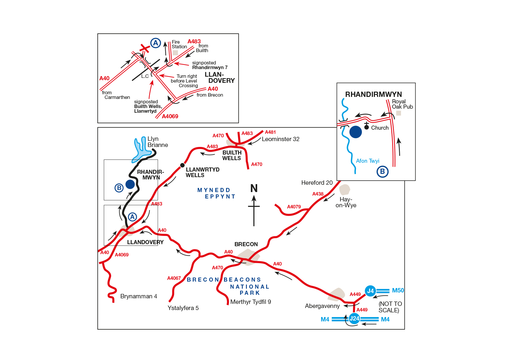
- Do not follow sat nav after Llandovery, please stick to the safe approach instructions
- No TV reception unless you have a suitable satellite dish.
- No mobile phone reception
Facilities
Key facilities
-
Flushing toilet
-
Showers
-
Club Site Wi-fi
-
Dedicated accessible facilities
-
Pets welcome
-
Designated dog walk
-
Shop
-
Washbasins
Pitches
-
Grass only pitch (no electric)
-
Grass pitch with electric hook-up
-
Hardstanding with electric hook-up
-
Grass pitch with electric hook-up for larger units
Site Facilities
-
Dedicated accessible facilities
-
Designated dog walk
-
Dishwashing facilities
-
Flushing toilet
-
Ice pack freezing
-
Motorhome service point
-
Showers
-
Washbasins
-
Washing Machines
-
Holiday Homes & Exclusive lodges
Site Features
-
Ball games
-
Pets welcome
-
Club Site Wi-fi
-
Shop
-
Caravans Allowed
-
Motorhomes Allowed
-
Tents Allowed
-
Trailer Tents Allowed
Pitch types
-
Grass only pitch (no electric)
-
Grass pitch with electric hook-up
-
Hardstanding with electric hook-up
-
Grass only pitch for larger units
-
Grass pitch with electric hook-up for larger units
-
Seasonal Pitches
Activities
-
Fishing (licence may be required)
-
Public house within one mile