News
We bring you the latest News for campers and caravanners.
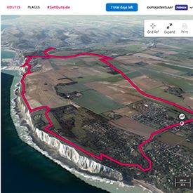
Plan better walks with 3D OS maps
Planning your next walking, hiking or outdoors adventure just got a lot easier thanks to a new 3D route planning service launched by Ordnance Survey (OS).
Recently named the UK Outdoor Industries Association’s Digital Product of the Year, the OS Maps app now benefits from new Aerial 3D technology, purposely designed to help outdoor enthusiasts stay safe, view routes as never before and discover new places to visit.
Over 750,000 publicly shared routes on the app benefit from the new Aerial 3D viewing tool including thousands of professional routes published by walking, cycling and mountaineering publications and organisations.
Nick Giles, Ordnance Survey Leisure Managing Director, says: “The introduction of the Aerial 3D viewing tool is another major step in making the outside enjoyable, accessible and safe for all. The new feature is perfect for anyone thinking of hiking, biking or climbing in Britain. It helps them to plan in accordance with their skills and experience. And importantly, being able to see routes clearly in this way should help people get inspired to do more in the great outdoors and at the same time keep safe. There’s nothing else like it available, and this is the first of a number of exciting new features we shall be introducing over the coming months.”
Subscribers to OS Maps can start using the new Aerial 3D function right away, but those who don’t subscribe can explore its benefits with a seven-day free trial. With that free trial you can also get access to digital versions of all 607 of OS’s Explorer and Landranger paper map titles.
You can find out about great discount offers your Club membership gets you on OS products on the Club's website.
MORE »
DAVID GUEST | 03 April 2017